Schokland and Surroundings: In prehistoric times, Schokland was part of the mainland. At the end of the Middle Ages, Schokland became an island, partly due to human intervention and the rising sea level. The island of Schokland was to low for habitation, the people lived on three dwelling mounds: Oud Emmeloord, Middelbuurt and Zuidert. The low island of Schokland was frequently damaged by storms and floods. During severe storms people were not even safe on top of the dwelling mounds. The Government of the Netherlands ordered the evacuation of the residents of Schokland in 1859. In 1942, the surrounding sea of Schokland was reclaimed and drained as a polder, the Noordoostpolder. Schokland became part of the mainland again. Nowadays, Schokland is an archaeological site and open air museum. For centuries, the people of the Netherlands are building dikes to protect their land against the sea and creating polders to provide more farmland. The Noordoostpolder is one of the more than three thousand Dutch polders. Schokland and Surroundings were declared a UNESCO World Heritage in 1995.
www.werelderfgoedfotos.nl © Copyright World Heritage Photos

Schokland and Surroundings: The Waterstaatskerk is situated on a dwelling mound (terp). The island of Schokland was to low for habitation, people lived on three dwelling mounds: Zuidert, Emmeloord and Middelbuurt. The low island of Schokland was frequently damaged by storms and floods. During severe storms, people were not even safe on the dwelling mounds. In 1859, the Dutch Government ordered the evacuation of the residents of Schokland.
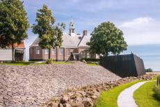
Schokland and Surroundings: The Waterstaatskerk is situated on a dwelling mound (terp). The island of Schokland was to low for habitation, people lived on three dwelling mounds: Zuidert, Emmeloord and Middelbuurt. The low island of Schokland was frequently damaged by storms and floods. During severe storms, people were not even safe on the dwelling mounds. In 1859, the Dutch Government ordered the evacuation of the residents of Schokland.
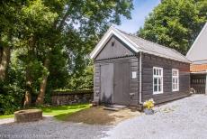
Schokland and Surroundings: The oldest building on the former island of Schokland is situated at Middelbuurt. The barn houses the ice boat, a boat fitted with runners (skates), but without a sail. During winter, when the sea was frozen, the boat was pushed over the ice to the mainland to purchase food supplies. The boat was also used to transport ill people to the hospital on the mainland.
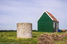
Schokland and Surroundings: A water well next to a tiny wooden family house in Middelbuurt, a former fishing village. In the prehistoric era, Schokland was part of the mainland. In the Middle Stone Age, Schokland was already inhabited by farmers and fishermen. At the end of the Middle Ages, Schokland became an island due to the rising sea level and erosion. In 1858, the island of Schokland was about 4 km long and about 500 metres wide.
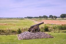
Schokland and Surroundings: The cannon was used as a warning system in case of high water. Two warning shots were fired in case of high water, three warning shots, the water level reaches the top of the dike and four warning shots meant a dike breach. For centuries, the inhabitants of the island struggled against the sea and to survive the harsh living conditions. Nowadays, the former island is a symbol of the traditional Dutch struggle against the sea.
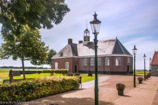
Schokland and Surroundings: The Waterstaatskerk (Water Management Church) was designed and built by the engineers of the Dutch Water Management, the Rijkswaterstaat, the church was built in 1834 and is surrounded by the small wooden houses of the small village of Middelbuurt. Nowadays, Middelbuurt is an open air museum. Schokland and Surroundings were declared a UNESCO World Heritage in 1995.
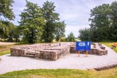
Schokland and Surroundings: The church of Ens dates back to 1300, only the base remains. The low island of Schokland was frequently damaged by storms and floods. The church of Ens was destroyed by the major storm flood of 1825. Nowadays, the church is a burial monument. The ruins of the church of Ens are situated at the Zuidpunt, the South Point of the former island of Schokland. Nowadays, Schokland is a unique cultural and historic monument.
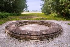
Schokland and Surroundings: Schokland was an important orientation point for seafarers on the former Zuiderzee, now called Lake IJsselmeer. The lighthouse at the Zuidpunt (South Point) was situated on a crucial point in the IJsseldelta. The lighthouse at the Zuidpunt was completely destroyed by the storm flood of 1825. Now, the foundation lies in the middle of the polder. The foundation of the lighthouse is a reconstruction.
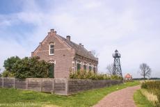
Schokland and Surroundings: The house of the lighthouse keeper, lighthouse and the office of the harbour master, called the Misthoorn, the Foghorn. The building once housed a foghorn, the deep roaring sound was used to warn ships in foggy weather. The buildings are situated on the former harbourside of the artificial dwelling mound Emmeloord. Emmeloord is situated at the North Point of Schokland. Nowadays, the former harbour lies in the middle of the polder.
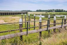
Schokland and Surroundings: The Noordoostpolder was reclaimed from the sea in 1942. The first years after the reclamation, the Noordoostpolder was wild reedland. During World War II, the polder offered shelter to Dutch resistance fighters against the Nazi-German occupation of the Netherlands and also a hiding place for Jews trying to escape the Nazi's. Schokland and its surroundings were inscribed on the UNESCO World Heritage List in 1995.
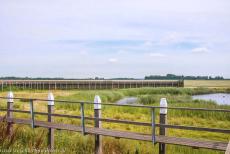
Schokland and Surroundings: The former harbour of Oud Emmeloord is situated at the North Point. When Schokland was still an island, the paths connecting the three dwelling mounds were often flooded, so wooden walkways were constructed. The low parts of the island of Schokland were to low and boggy to be inhabited. Oud Emmeloord was the largest dwelling mound on the island. In 1859, the residents of Schokland were evacuated and were never allowed to return.
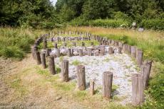
Schokland and Surroundings: The Geo-garden, the Gesteentetuin. After the reclamation of the Noordoostpolder in 1942, numerous boulders were found, the boulders came from Scandinavia and were brought here during the Ice Ages by the huge ice flows. Nowadays, the former island of Schokland is an archaeological site and an open air museum. The Noordoostpolder is one of the more than three thousand Dutch polders.
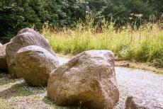
Schokland and Surroundings: Several large boulders in the Geo-garden, the Gesteentetuin. The Gesteentetuin is a geological garden, situated in the Schokkerbos, a varied forest. Stones from Scandinavia were brought here during the Ice Ages by the ice flows. The Schokkerbos is situated on the west side of the former island of Schokland. Schokland is also an archaeological site, the archaeological finds are exhibited in the Schokland Museum.
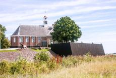
Schokland and Surroundings: The Waterstaatskerk (Water Management Church). The former island of Schokland is still visible as a slightly raised area in the Noordoostpolder, the North East Polder. The Waterstaatskerk was built with the financial support of the Dutch Ministry of Water Management. The church was designed and built under the supervision of the engineers of the Dutch Water Management.
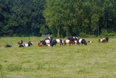
Schokland and Surroundings: Until the 17th century, there was enough suitable soil for farming and cattle breeding. Storms and floods caused severe damage to the island of Schokland, it lost their farmland to the sea. The surrounding sea was reclaimed in 1942. The island of Schokland became part of the Noordoostpolder and is now safe behind the dikes. Nowadays, Dutch Belted Cattle, Lakenvelder Cattle, are grazing in the Dutch Noordoostpolder.
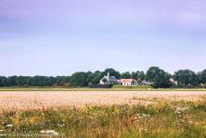
Schokland and Surroundings: In prehistoric times,Schokland was part of the mainland. At the end of the Middle Ages, Schokland became an island, due to the rising sea level and partly to human intervention. In 1942, the surrounding sea was reclaimed and drained as a polder, the Noordoostpolder. Schokland became part of the mainland again. Schokland became an island in the Noordoostpolder.
